
PFAS on Spokane's West Plains: Sources, Pathways, and Private Wells

This educational map, updated with new information, shows the Fairchild and Airport investigation zones, more rural fire stations, and more roads. The general boundary is the geologically-defined West Plains Aquifer, enclosing around 4,000 rural homes with private wells. You’ll see the general water flow direction, both surface and in the paleo channels, northeast towards the Spokane River.
PFAS “Heat Map” of the West Plains

Dr. Chad Pritchard’s compilation of a thousand+ well tests compares specific parts of the West Plains neighborhood. An estimated 50% of all homes, in locations shown blue, are unlikely to have contaminated water. Pink and Red show higher risk, for which the Coalition recommends a PFAS drinking water test right away.
3D Sideview of Underground Water
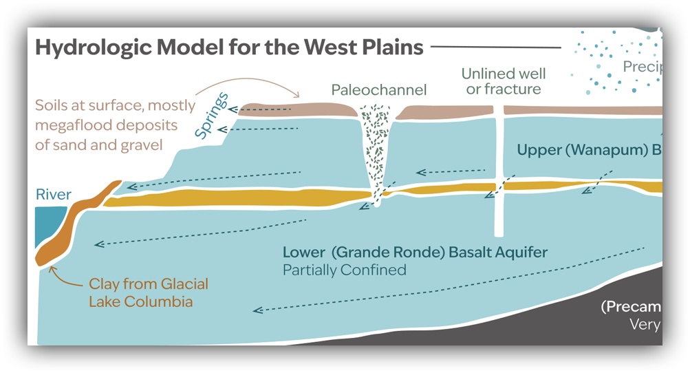
At Eastern Washington University, Dr. Chad Pritchard’s geology career has focused on West Plains rocks and water. This illustration links the invisible parts of the aquifer with the watershed features we can see. Because home wells have depths ranging from 40 to 700 feet, this third dimension of source and flow shows the complexity of risk and cleanup solutions.
Funded in part by a Public Participation Grant from the Washington State Department of Ecology